
Introduction
Virtual RINEX data is generated by the network management software for a user-defined location and time period. Virtual RINEX provides the same data that would have been observed at a user-defined location, where there is no physical reference station, but which lies within the area covered by a network of reference stations.
X-pos provides Virtual RINEX Data service. Virtual RINEX files can be generated using real X-pos reference data and network corrections provided by Leica GNSS Spider.
Virtual RINEX requires GNSS network correction data. Obtaining a RINEX file referring to a virtual location is possible for periods of time and positions for which an active cluster has successfully provided sufficient network correction data and pushed it to the X-pos data repository.
The Virtual RINEX service can be accessed on the “Post-Processing > RINEX Data” page. Toggling the “Virtual RINEX” slider changes the layout of the “RINEX Data” page to support the elements required for a Virtual RINEX request, enabling users to enter their input requirements.
Only users with a suitable subscription can benefit from the Virtual RINEX service. According to the properties of the subscribed article, there may be a limitation on usage of the Virtual RINEX Data service, expressed in epochs. Please note that the Virtual RINEX option is only available on the SBC Portal if the “Enable Virtual RINEX Service” slider is toggled on the Settings > X-pos > General page.
Virtual RINEX Request
Toggling the “Virtual RINEX” slider on the “RINEX Data” page adapts it to the Virtual RINEX Data service.
To the right of the page, users can enter a name and number for the output Virtual RINEX file, but this is not compulsory. If the user does not enter this information, the default values displayed as placeholders in the corresponding fields will be used in the output RINEX files.
Latitude and longitude are the only mandatory fields when submitting a Virtual RINEX request. These define the input position for the request and will also be the approximate position displayed in the header of the virtual observation file.
There are two ways to provide the input position for a Virtual RINEX request.
Option 1
-
Users can either manually enter input coordinates in the dedicated fields on the “Virtual RINEX Data” page or copy and paste them in one of the listed formats:
-
-
Decimal degrees and N/S/E/W, for example: 37.68455 N; 97.34110 W;
-
Decimal degrees and plus/minus (latitude preceded by a minus sign if it is south of the equator, and longitude if it is west of the prime meridian), for example: 37.68455°; –97.34110°;
-
Degrees/minutes/seconds and N/S/E/W, i.e. DMS (minutes and seconds are fractions of a degree: Each minute is one-sixtieth of a degree, and each second is one-sixtieth of a minute) for example: 37°41'26" N; 97°20'0" W;
-
Degrees/minutes/seconds and plus/minus, for example: 37°41'26"; –97°20'0".
-
-
If needed, pasted coordinates will be automatically converted and displayed in sexagesimal degrees (Degrees/minutes/seconds and N/S/E/W), which is the SBC's default format for input coordinates.
-
The validity ranges for latitude are [-90.0000000, 90.0000000] or [-90° 0’ 0.00’’, +90° 0’ 0.00’’], and for longitude are [-180.0000000, 180.0000000] or [-180° 0’ 0.00’’, +180° 0’ 0.00’’]. There is no limitation on the number of decimal places supported after the comma: values pasted by the user will be truncated in the GUI if necessary, but stored as they are for computation.
-
There are validation checks in place to ensure the usability of the inputted coordinates, and error messages will be displayed if the user tries to input coordinates that are out of range or invalid.
Option 2
-
The cursor on the map can also be used to select the input position for the Virtual RINEX files by dragging and dropping it onto the required location. Moving the cursor on the map updates the latitude and longitude fields immediately (and vice versa).
-
When you first open the “Virtual RINEX Data” page on SBC, the latitude and longitude fields are populated with the position of the cursor on the map. By default, the map is centred. If the content of the latitude and longitude boxes is manually deleted without new values being entered, the latitude and longitude will not be left blank, but will instead be populated with the latest input values used in the most recently triggered Virtual RINEX Data request. The N/S and E/W fields will remain as they were before the cursor coordinates were deleted. Therefore, the latitude and longitude fields will never be blank.
-
The necessary condition for submitting a Virtual RINEX Data request is that RINEX and network correction data are available for the requested time span and position for the real stations involved in computing the virtual file. Regardless of the method used to enter the input coordinates, the real reference stations involved in the computation of the Virtual RINEX file will be displayed on the map in blue. Furthermore, the auto-selected reference stations that are shown in blue are all configured and processed in the same cluster.
-
These depend on the cluster configuration used for the network processing. The stations involved vary according to the user-defined input position. The colour coding of the site markers indicates the availability of RINEX data (green = 80 – 100 %, yellow = 30 – 80 %, red = 0 – 30 %), but network correction data is only available if the sites turn blue.
-
If this is the case, the “Submit” button on the Virtual RINEX page becomes available and the available constellations, according to the data of the real reference stations contributing to the Virtual RINEX computation, are listed on its left.
-
It is not mandatory to enter a value for the ellipsoidal height. If no value is entered, the height of the master station will be used as the default, provided that master and auxiliary sites are available for the user's position and time period. The maximum supported value for the ellipsoidal height is 9,999.99 metres.
-
The output observation rate for Virtual RINEX files can be customised and is currently limited to multiples of one second. The default observation rate is 1 second. Alternative rates can be selected from the list provided in the drop-down menu on the Virtual RINEX page before submitting the request.
-
After clicking “Submit”, users are asked to confirm their request. If they confirm it, they are immediately redirected to the “Post-Processing > Results” page.
-
Once the Virtual RINEX request has been finalised, Virtual RINEX files can be downloaded from this page.
-
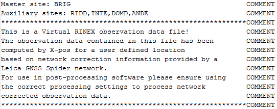
The real reference stations involved in computing the Virtual RINEX are summarised in the header section of the file. For example:
-
This makes the master and auxiliary stations known.